Denver, Colorado, March 15, 2023 – Vista Gold Corp. (NYSE American and TSX: VGZ) (“Vista” or the “Company”) today announced results of its most recent surface exploration program on two specific areas within the exploration licenses (“ELs”) at the Company’s Mt Todd gold project (“Mt Todd” or the “Project”). Both targets returned excellent anomalous gold assays from surface sampling, including up to 4.0 grams of gold per tonne (“g Au/t”) at the Irwins target.
Frederick Earnest, President and CEO of Vista Gold Corp., stated, “The ELs at Mt Todd encompass 1,650 km2 and are largely underexplored. As part of our annual exploration program for the ELs, we collected more than 600 rock chips and soil samples from an area of interest covering ~ 1.6 km2 on the Cullen-Australis Structural Corridor. The results demonstrate strong geologic similarities to the area in the mining licenses where we previously delineated four highly prospective exploration targets through our 2021-22 drilling program. We are encouraged by the tenor of these results, which reinforce our belief that the Mt Todd land package has tremendous discovery potential.”
Exploration License Potential
There are a significant number of known mineralization occurrences and indicators within the ELs. The ELs share several similarities to the Project mining licenses (“MLs”). The most important shared characteristics between the Batman-Driffield Structural Corridor (located on the MLs) and the Cullen-Australis Structural Corridor to the north and east on the ELs are similar structural controls, lithologies, alteration patterns, and granitic intrusions. Vista’s recent exploration drilling program highlighted the strong possibility that the four newly identified targets are structurally connected to the Batman deposit to the south and the Quigleys deposit to the north. Given the similarities seen between the two structural corridors and the number of mineralized occurrences on the ELs, the prospects of delineating deposits of similar scale and grade are highly encouraging.
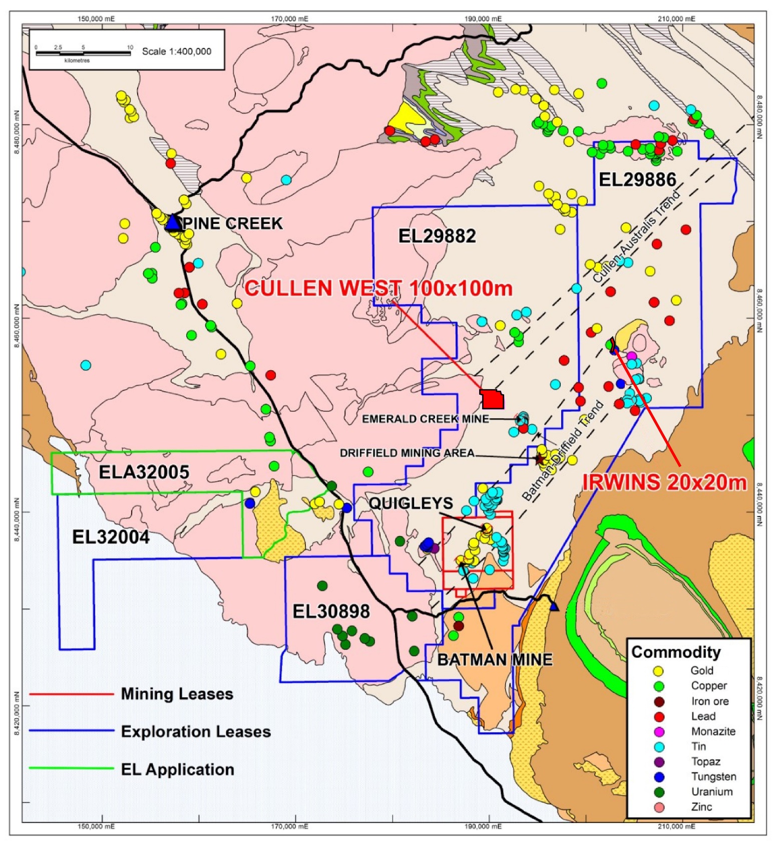
Figure 1 below shows the boundaries of the ELs and MLs, underlying geology, known mineral locations, predominant types of mineralization identified to date, and the two areas of interest (Irwins and Cullen West) within the Cullen-Australis Structural Corridor that were sampled during the 2022 annual ELs exploration program.
Figure 1 – Mt Todd Land Package

Vista’s 2022 ELs exploration program collected a total of 60 rock chip, 556 soil, and 19 stream sediment samples. We concentrated on two areas within the Cullen Australis Trend. Both areas showed encouraging anomalous metal values through previous widely spaced surface sampling programs. Additionally, these areas exhibit similar lithology, alteration, proximity to young granitic bodies, structure, and magnetic anomalies similar to those found at the Batman deposit.
2022 Soil Programs
Cullen West Area
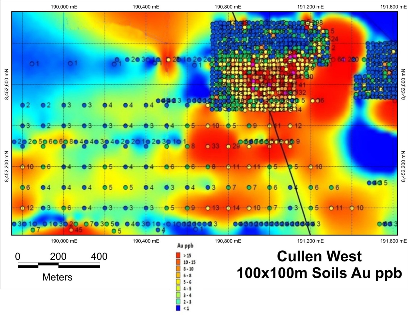
Six lines of the 100x100m soil sampling program contained 121 samples as shown in Figure 2. Table 1 details the most significant gold assays, with the three highlighted rows showing the highest-grade samples.
Figure 2 – Detailed Surface Locations of the Infill Program

Note: ppb = parts per billion and 1,000 ppb = 1 ppm
ppm = parts per million and1 ppm = 1 gram/tonne
Table 1 – Cullen West Most Significant Soils Samples Collected (2022 Program)
| Sample ID | GDA94 East | GDA94 North | Au ppb | Cu ppm | Pb ppm | Zn ppm | As ppm | Bi ppm | Sn ppm | W ppm |
| VS70438 | 190700 | 8452500 | 12 | 5 | 18 | 25 | 28 | 1.23 | 2.4 | 2.67 |
| VS70439 | 191100 | 8452400 | 12 | 12 | 34 | 35 | 57 | 0.97 | 3.95 | 5.16 |
| VS70440 | 191000 | 8452400 | 11 | 37 | 48 | 51 | 321 | 1 | 4.49 | 4.77 |
| VS70443 | 190700 | 8452400 | 10 | 25 | 84 | 86 | 401 | 1.4 | 4.58 | 6.27 |
| VS70475 | 190700 | 8452300 | 33 | 66 | 213 | 221 | 1460 | 0.96 | 4.86 | 6.49 |
| VS70476 | 190800 | 8452300 | 29 | 52 | 72 | 63 | 1031 | 1.21 | 3.88 | 6.18 |
| VS70477 | 190900 | 8452300 | 10 | 36 | 95 | 61 | 601 | 2.44 | 7.52 | 7.81 |
| VS70478 | 191000 | 8452300 | 37 | 37 | 35 | 39 | 308 | 1.56 | 3.73 | 3.09 |
| VS70479 | 191100 | 8452300 | 14 | 23 | 38 | 46 | 20 | 0.63 | 1.52 | 1.46 |
| VS70480 | 191200 | 8452200 | 10 | 31 | 32 | 20 | -10 | 0.99 | 1.83 | 1.27 |
| VS70483 | 190900 | 8452200 | 11 | 42 | 38 | 44 | 440 | 2.2 | 4.27 | 7.19 |
| VS70484 | 190800 | 8452200 | 11 | 18 | 57 | 72 | 318 | 0.64 | 2.36 | 2.07 |
| VS70494 | 189800 | 8452200 | 10 | 25 | 61 | 29 | 17 | 10.1 | 5.51 | 4.5 |
| VS70522 | 191400 | 8452000 | 10 | 18 | 24 | 22 | -10 | 0.96 | 3.9 | 3.67 |
| VS70523 | 191300 | 8452000 | 11 | 39 | 92 | 62 | 125 | 4.33 | 5.27 | 9.24 |
| VS70527 | 190900 | 8452000 | 10 | 36 | 56 | 47 | 216 | 1.58 | 3.95 | 5.11 |
| VS70528 | 190800 | 8452000 | 14 | 46 | 82 | 156 | 271 | 2.11 | 6.04 | 9.34 |
| VS70529 | 190700 | 8452000 | 13 | 101 | 195 | 161 | 487 | 1.64 | 8.98 | 14.04 |
| VS70538 | 189800 | 8452000 | 12 | 18 | 74 | 43 | -10 | 7.4 | 8.24 | 18.19 |
Note: 1,000 ppb equals 1 ppm and 1 ppm equals 1 gram/tonne.
10,000 ppm equals 1 percent.
Irwins Area
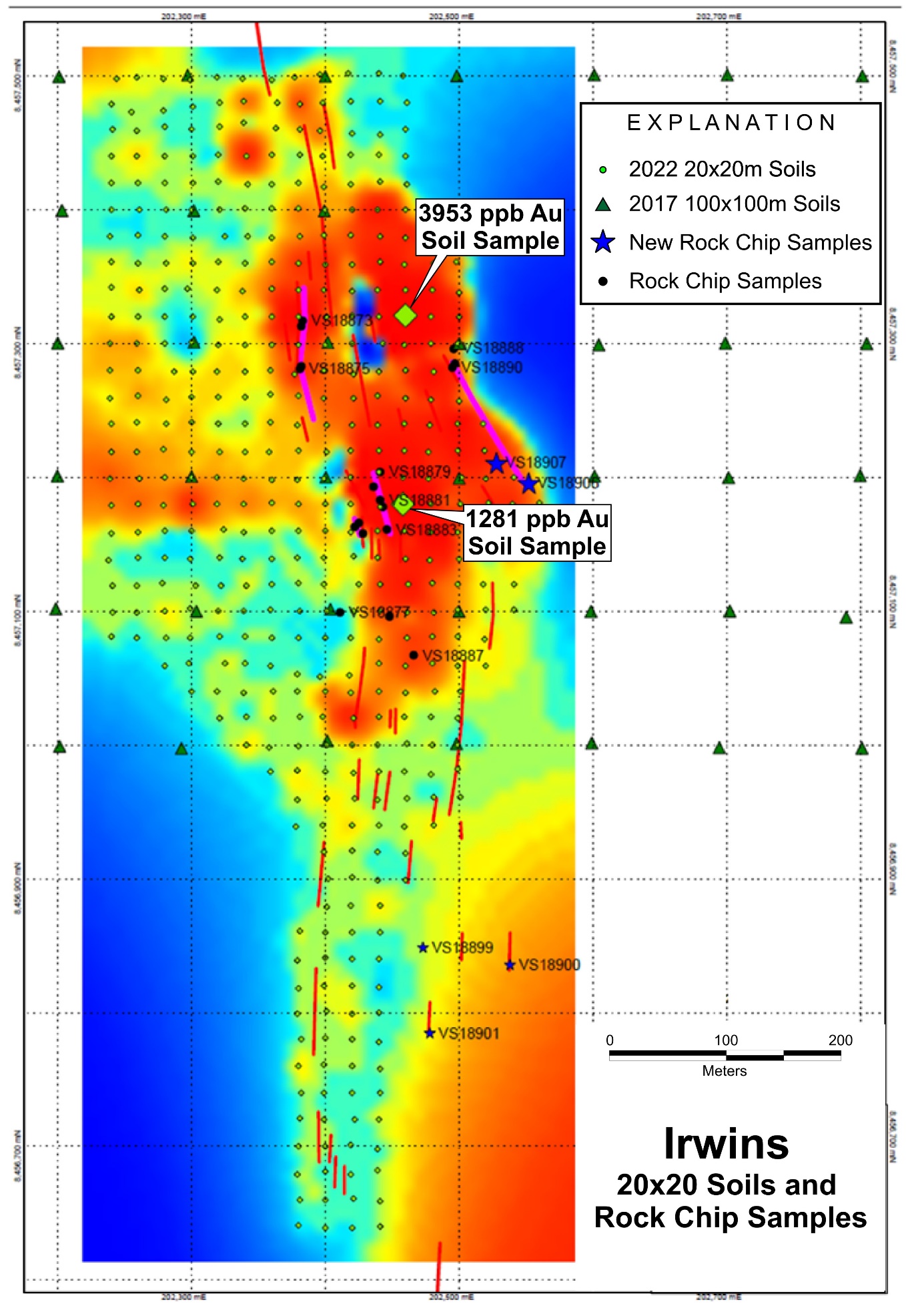
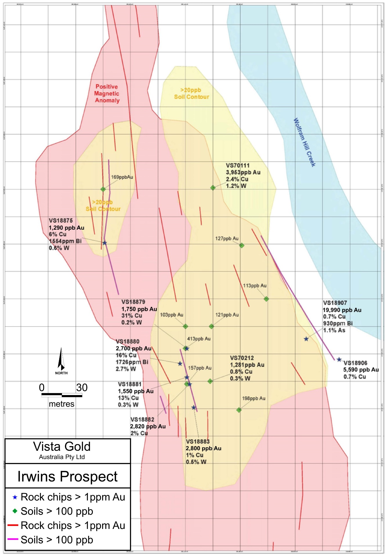
The soil sampling program at Irwins consisted of 44 lines with samples collected on a 20x20m pattern. A total of 436 samples were collected. Some of the samples show a significant high-grade anomalous gold pattern that corresponds with high-grade copper, tungsten, and elevated bismuth and tellurium. At the Batman deposit, we see similar trends with the gold, copper, bismuth, and other sulfide metals. The highest two soil samples collected had gold grades of 3,953 ppb (3.953 g Au/t) and 1,281 ppb (1.281 g Au/t), respectively. Figures 4 and 5 provide greater detail on the Irwins soil sampling program. The RED lines are dolerite dike locations. The PURPLE lines show the locations of historic workings. As can be seen, the two parallel each other and the highest soil grades also align with these trends. The area in the southeast corner of the figure is shown with higher grades because of the presence of the dolerite dikes. Table 2 details the most significant soil samples collected.
Table 2 – Irwins Area Most Significant Soil Samples
| Sample ID | GDA94 East | GDA94 North | Au ppb | Cu ppm | As ppm | Ag ppm | Bi ppm | W ppm |
| VS70057 | 202439 | 8457400 | 55 | 2134 | -10 | -1 | 224.7 | 461.69 |
| VS70082 | 202441 | 8457361 | 76 | 1773 | 1489 | -1 | 128.11 | 491.29 |
| VS70097 | 202460 | 8457340 | 75 | 2399 | 467 | -1 | 61.86 | 1426.91 |
| VS70107 | 202380 | 8457320 | 169 | 4724 | 2745 | -1 | 1395.45 | 7887.56 |
| VS70111 | 202460 | 8457321 | 3953 | 23942 | 4948 | 134 | 1811.26 | 11778.2 |
| VS70112 | 202479 | 8457320 | 83 | 473 | -10 | -1 | 46.65 | 761.11 |
| VS70140 | 202481 | 8457279 | 127 | 5657 | 137 | 1 | 32.54 | 1396.74 |
| VS70167 | 202478 | 8457239 | 55 | 311 | -10 | -1 | 12.73 | 114.44 |
| VS70168 | 202499 | 8457240 | 113 | 1141 | -10 | -1 | 0.25 | 8.93 |
| VS70180 | 202440 | 8457220 | 103 | 5709 | -10 | -1 | 84 | 477.46 |
| VS70181 | 202459 | 8457220 | 121 | 2322 | -10 | -1 | 108.63 | 2012.3 |
| VS70183 | 202499 | 8457220 | 76 | 373 | -10 | -1 | 14.15 | 149.07 |
| VS70195 | 202440 | 8457204 | 413 | 7692 | -10 | -1 | 176.8 | 1306.95 |
| VS70196 | 202458 | 8457200 | 67 | 1036 | -10 | -1 | 36.47 | 150.74 |
| VS70197 | 202477 | 8457199 | 58 | 701 | -10 | -1 | 38.2 | 741.96 |
| VS70211 | 202441 | 8457178 | 157 | 1625 | -10 | -1 | 56.08 | 916.13 |
| VS70212 | 202458 | 8457180 | 1281 | 8412 | -10 | -1 | 494.1 | 2659 |
| VS70230 | 202479 | 8457159 | 198 | 752 | -10 | -1 | 140.15 | 138.14 |
| VS70246 | 202460 | 8457139 | 60 | 959 | -10 | -1 | 66.78 | 146.46 |
| VS70263 | 202462 | 8457120 | 63 | 764 | -10 | -1 | 28.16 | 80.05 |
Figure 4 – Irwins Area Soil Geochemistry Map.

RED Lines are dolerite dike locations
PURPLE Lines are locations of historic workings
Figure 5 – Irwins Area – High-grade Sample Locations on Magnetic Anomaly

Sampling Methodology
The sampling method and approach for the surface geochemistry and grab samples is as follows:
- Soil samples are planned on a regular grid and a sample sheet is generated.
- GPS is used to locate sample positions and a pelican pick is used to clear debris and any topsoil from the sample location 3.
- The hole is dug to the B horizon and 7 to 10 kg of soil is collected and coarse sieved to remove stones, etc.; a fine mesh is then employed and the entire sample recovered post sieving is bagged.
- Soil sampling is usually undertaken in the dry season; however, if wet samples are obtained, they are dried in the logging shed prior to sieving.
- Sample bags are calico and purchased pre-numbered; these are then packaged in groups of 5 for transportation to NAL, an independent ISO 9000 certified lab, Pine Creek, NT and Genalysis Laboratory Services Pty Ltd, Perth, WA, which is also independent from Vista.
- As the site is closed to public access, no special security measures are undertaken.
- A sample submission sheet is sent to the lab, detailing required methodology, and number of samples.
- No identifying data relating to sample location is recorded on the bags submitted or the paperwork beyond bag numbers.
Rock chip and soil geochemical samples are routinely collected to determine if the potential exists for anomalous gold values below the surface. The presence of anomalous gold grades is not a guarantee of subsurface mineralization. While both rock chip and soil samples have sampling procedures, it is not considered rigorous enough to be relied upon for use in the estimation of mineral resources. Surface soil and rock chip samples are merely considered to be potential indicators of subsurface mineralization. Since the rock chip and soil assays are not used in mineral resource estimation, it is rare that any additional QA/QC or check assaying would be completed. The data are used on an as received basis.
It is the QP’s (as defined below) opinion that the sample preparation methods and quality control measures employed before dispatch of samples to an analytical or testing laboratory ensured the validity and integrity of samples taken.
John Rozelle, Vista’s Senior Vice President, a Qualified Person (“QP”) as defined in accordance with subpart 1300 of Regulation S-K under the United States Securities Exchange Act of 1934, as amended (“S-K 1300”) and by Canadian National Instrument 43-101 – Standards of Disclosure for Mineral Projects (“NI 43-101”), has verified the data underlying the information contained in and has approved this press release. The information contained in this press release does not change any of the mineral resources or reserves estimates contained in Vista’s technical report summary entitled “S-K 1300 Technical Report Summary - Mt Todd Gold Project - 50,000 tpd Feasibility Study – Northern Territory, Australia” with an effective date of December 31, 2021, an issue date of February 9, 2022 and an amended date of February 7, 2023 available on EDGAR or the technical report entitled “NI 43-101 Technical Report - Mt Todd Gold Project - 50,000 tpd Feasibility Study – Northern Territory, Australia” with an effective date of December 31, 2021 and an issue date of February 9, 2022 available on SEDAR.
The information contained in this press release is provided to inform the reader of the growth of our geologic understanding of the Project. There has been insufficient exploration to define a mineral resource with respect to the exploration target areas and it is uncertain if further exploration will result in the exploration target areas being delineated as a mineral resource.
About Vista Gold Corp.
Vista is a gold project developer. The Company’s flagship asset is the Mt Todd gold project located in the Tier 1, mining friendly jurisdiction of Northern Territory, Australia. Situated approximately 250 km southeast of Darwin, Mt Todd is one of the largest and most advanced undeveloped gold projects in Australia and has the potential to be one of the top five gold producers in Australia. All major environmental and operating permits have now been approved.
For further information, please contact Pamela Solly, Vice President of Investor Relations, at (720) 981-1185 or visit the Company’s website at www.vistagold.com.
Forward Looking Statements
This press release contains forward-looking statements within the meaning of the U.S. Securities Act of 1933, as amended, and U.S. Securities Exchange Act of 1934, as amended, and forward-looking information within the meaning of Canadian securities laws. All statements, other than statements of historical facts, included in this press release that address activities, events or developments that we expect or anticipate will or may occur in the future, including such things as our belief that the results of the recent surface exploration program returned excellent anomalous gold assays and demonstrate strong geologic similarities to the area in the mining licenses where we previously delineated four highly prospective exploration targets through our drilling program completed in 2022; our belief that the Mt Todd land package has tremendous discovery potential; our belief that the Els share several similarities to the Project MLs; our belief that the most important shared characteristics between the Batman-Driffield Structural Corridor (located on the MLs) and the Cullen-Australis Structural Corridor to the north and east on the ELs are similar structural controls, lithologies, alteration patterns, and granitic intrusions; our belief that Vista’s recent exploration drilling program highlighted the strong possibility that the four newly identified targets are structurally connected to the Batman deposit to the south and the Quigleys deposit to the north; our belief that the prospects of delineating deposits of similar scale and grade are highly encouraging; and our belief that Mt Todd is one of the largest undeveloped gold project in Australia and has the potential to be one of the top five gold producers in Australia, are forward-looking statements and forward-looking information. The material factors and assumptions used to develop the forward-looking statements and forward-looking information contained in this press release include the following: our forecasts and expected cash flows; our projected capital and operating costs; our expectations regarding mining and metallurgical recoveries; mine life and production rates; that laws or regulations impacting mine development or mining activities will remain consistent; our approved business plans, our mineral resource and reserve estimates and results of preliminary economic assessments; preliminary feasibility studies and feasibility studies on our projects, if any; our experience with regulators; our experience and knowledge of the Australian mining industry and our expectations of economic conditions and the price of gold. When used in this press release, the words “optimistic,” “potential,” “indicate,” “expect,” “intend,” “hopes,” “believe,” “may,” “will,” “if,” “anticipate” and similar expressions are intended to identify forward-looking statements and forward-looking information. These statements involve known and unknown risks, uncertainties and other factors which may cause the actual results, performance or achievements of the Company to be materially different from any future results, performance or achievements expressed or implied by such statements. Such factors include, among others, uncertainty of resource and reserve estimates, uncertainty as to the Company’s future operating costs and ability to raise capital; risks relating to cost increases for capital and operating costs; risks of shortages and fluctuating costs of equipment or supplies; risks relating to fluctuations in the price of gold; the inherently hazardous nature of mining-related activities; potential effects on our operations of environmental regulations in the countries in which it operates; risks due to legal proceedings; risks relating to political and economic instability in certain countries in which it operates; uncertainty as to the results of bulk metallurgical test work; uncertainty as to completion of critical milestones for Mt Todd; as well as those factors discussed under the headings “Note Regarding Forward-Looking Statements” and “Risk Factors” in the Company’s latest Annual Report on Form 10-K as filed in February 2023 and other documents filed with the U.S. Securities and Exchange Commission and Canadian securities regulatory authorities. Although we have attempted to identify important factors that could cause actual results to differ materially from those described in forward-looking statements and forward-looking information, there may be other factors that cause results not to be as anticipated, estimated or intended. Except as required by law, we assume no obligation to publicly update any forward-looking statements or forward-looking information; whether as a result of new information, future events or otherwise.


